Individual project

BHP + Resources Technology and Critical Minerals Trailblazer

Digitising mining features

A phased automation project validating drill patterns from aerial imagery, and drill tables, replacing hazardous manual checks with faster, higher-coverage evidence.

Timeline
August 2024 - August 2025
Analysis
40x data volume
QA/QC
2 hours to under 5 min
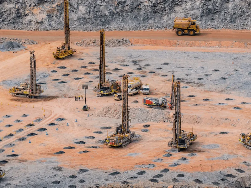
Mining operations data being reviewed for drill pattern validation.
Drill and blast mining using semi-autonomous drill rigs
This automated reporting represents a step function improvement for BHP operations.
BP

BHP project stakeholder

Internal project feedback - BHP

Recognition and proof

Project signals

INCITE2026

Industrial technology

2026 INCITE Awards — Industrial Technology Merit

The Automated Drill Rig GPS Drift Detection Tool is an industrial analytics application that automates the detection of drill rig GPS calibration drift - a problem that, left undetected, carries real consequences for productivity, safety, and operational cost.

iAwards

Innovation Award

2026 iAwards Chief Judge Innovation Award

The tool tackles a problem that quietly costs the mining industry time and money: keeping drill rig GPS calibration accurate.

Project overview

From manual spot checks to automated drill-pattern validation.

Mining is an inherently dangerous and costly process, so BHP is always looking for ways to maintain safety while increasing operational efficiency. BHP implemented semi-autonomous drill rigs in order to reduce the need for people on the active mining surface, however this left them with a problem - validating the location of the drilled holes. The drill rigs have GPS sensors and drill according to a plan. After drilling, drones capture images of the site to verify the drilled locations. Validating drill patterns and detecting drift in the GPS sensors was a manual process that analysed only 2% of the holes in a pattern, could take hours to complete. This manual process could only detect GPS drift once it had become a significant issue, requiring drill rigs to be taken out of operation for inspection and maintenance - a costly procedure.

CIDS worked with BHP, with funding from the Resources Technology and Critical Minerals Trailblazer, to design a phased automation strategy. The first phase used reported drill locations as reference points, then extracted features from cropped aerial imagery to identify drill hole locations, flag unreliable data, and detect calibration issues such as GPS drift.

Validation against manually tagged data showed accuracy within approximately one pixel. In tested cases the workflow frequently verified more than 70% of holes, and sometimes more than 95%. The increased number of holes used for analysis means that it is now possible to identify GPS drift on individual rigs well before it becomes a significant issue. This in turn allows BHP to perform pro-active maintenance on these rigs, reducing out-of-cycle maintenance and increasing their operational efficiency. BHP estimates that avoiding out-of-cycle maintenance will save them $1 Million per year across the 6 Iron Ore sites which they operate in WA.

The second phase of this project focused on delivering a software product that could be integrated into the BHP infrastructure.  By working closely with the minesite operators, CIDS was able to rapidly test and deploy software into the locked down BHP systems. Thanks to this seamless integration, our software tool has now become part of business as usual for BHP WA Iron Ore operations and is now being used to validate drill pattern on every site.
A project team reviewing mapped data and validation evidence.
The system reframed the task: instead of searching entire images for every possible hole, it used reported drill locations to narrow the search space and focus the evidence.Accuracy within approximately one pixel

Before and after

4 operational shifts from the project

Digitising Mining Features

Before

After

Hole verification coverage

Manual checks covered around 2% of holes.

Hole verification coverage

Automated analysis often exceeded 70%, with tests above 95%.

More drift and calibration issues become visible.

QA/QC time

Teams spent roughly 2 hours processing and checking data.

QA/QC time

Automated reporting reduced QA/QC time to under 5 minutes.

Field evidence can move into operational decisions faster.

Precision and Specificity

Aggregate errors detected only when significant

Precision and Specificity

Errors detected on individual drill rigs before they impact operations

Rig calibration and GPS drift can be checked from evidence.

Maintance

Reactive, costly

Maintance

Proactive, efficient

Reduced unplanned downtime and maintenance costs

Have a challenge? Bring it to CIDS.

We bring together the expertise, technology and research capability to determine the right way forward.